Blog
Why Trade Areas Matter (And How We Build Them)


Every business that depends on physical location eventually asks the same question: who are my customers, and where do they come from? It sounds simple, but answering it accurately has historically required either expensive surveys or a lot of guesswork. Trade areas are how the industry has tried to solve that problem, and the methodology behind them has changed dramatically in recent years.
What Is a Trade Area?
A trade area is an estimate of where the visitors to a specific place live. Not a rough circle drawn around a pin on a map, but a probability surface derived from observed device behavior, built from the real movement patterns of real people.
The industry used to rely on the radius approach, which draws a circle of a fixed distance around a location and assumes everyone within it is a potential customer. The problem is that physical distance is a poor proxy for how people actually move. A two-mile radius in dense urban Chicago captures hundreds of thousands of people and dozens of competing options. The same radius in rural Wyoming captures almost no one. Drive-time estimates improve on this somewhat, but they still don’t account for the fact that people routinely cross busy highways to reach one store while ignoring a closer competitor, or that customers at a downtown coffee shop may commute in from twenty miles away every morning.
A genuine trade area reflects what people do rather than what we assume they do.
What Are Trade Areas Used For?
Across various industries, knowing where customers come from changes the quality of every question you can ask.
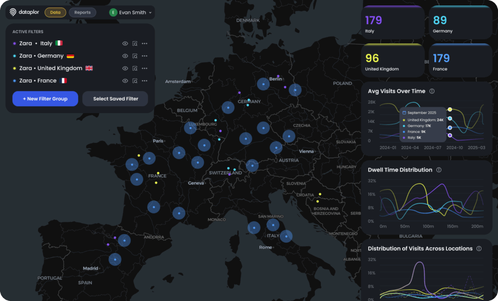
Site Selection: Opening a new location is one of the most capital-intensive decisions a business can make, and trade areas make it a sharper one. By mapping where current visitors live, you can assess whether a prospective site would draw from a genuinely new customer base or pull visitors away from an existing location. Two stores five miles apart might seem complementary until their trade areas reveal 70% overlap. Trade areas also help you find the gaps: areas with dense populations and long travel distances to any comparable option are exactly where expansion makes sense.
Competitive Intelligence: Trade areas let you see not just who your customers are, but who your competitors are drawing in. If a rival location is attracting customers heavily from a neighborhood that requires crossing a major highway to reach it, there may be an opportunity to serve those customers closer to home. If a competitor’s reach extends significantly farther than expected, that’s a signal about brand strength worth taking seriously. Understanding the geography of your competitive landscape is much harder without trade area data, and much easier with it.
Tenant Analysis: For landlords, investors, and developers, trade areas answer the question of true catchment. A prospective tenant’s claim about how far customers will travel is not the same as what the mobility data actually shows. Trade areas provide an objective basis for evaluating tenant quality and anchor value, and for understanding whether a retail property is drawing from the population density it needs to justify its lease terms.
Media Targeting: Knowing where your customers live tells you where to reach them before they ever leave for the store. Trade areas provide the geographic foundation for pre-visit advertising, enabling brands to concentrate spend in the neighborhoods that actually convert rather than broadcasting across an entire metro area. The result is more efficient campaigns and stronger attribution between ad exposure and in-store visits.
How We Build Trade Areas at Scale
Our trade area methodology pairs global population trends and makeup with 31.1 trillion location pings. (To visualize this number, imagine every ping is a penny. If you stack them, the pile would reach almost to Mars.) We received nearly 141 billion new pings in a single day last month, and that volume is accelerating.
The process of turning those pings into trade areas runs through six stages:
- Ingesting and filtering raw pings to remove noise and non-human signals
- Grouping the cleaned pings into visits against our global database of points of interest
- Building a device catalog that estimates where each person lives based on 24 months of location history
- Classifying those home locations using signals like time of day, day of week, and commercial versus residential density
- Generating the trade area surface that maps the geographic distribution of where visitors come from
- Recasting that surface into privacy-safe geometries appropriate for external use
The final output can be delivered in whatever geographic format a client needs, including US or Canadian census block groups, or EU local administrative units.
Start Using Trade Areas to Find Your Next Best Location
Where your customers come from is one of the most practically useful things you can know about a location. With meaningful accuracy, trade areas finally makes that answerable. And because the data is built on privacy-safe geometries that aggregate to census block group scale, you get the precision you need without compromising individual privacy. Talk to us today.


Get the full story
Subscribe for the latest on location intelligence, places data, and the trends behind better business decisions.