Geospatial Data: What It Is and Why Your Business Needs It

Blog

Geospatial Data: What It Is and Why Your Business Needs It

Geoff Michener
 Jan 30, 2026  •  7 min read

In today’s data-driven world, location data has become a crucial asset for staying competitive. From optimizing marketing campaigns to improving site selection, the ability to understand and utilize geospatial data can transform the way your business operates. Businesses across numerous industries use location information to enhance decision-making, predict customer behavior, and streamline operations.

In simple terms, geospatial data refers to information linked to a specific place on the surface of the earth. This data can consist of points of interest (POI), which provide geographic coordinates such as latitude and longitude, along with additional attributes and details on a given place. If you want to access valuable insights like POI data, providers like dataplor offer comprehensive location data to help you gain a competitive edge.

A study revealed that the geospatial data industry is growing rapidly, with the global GIS market projected to reach $14.5 billion by 2025.
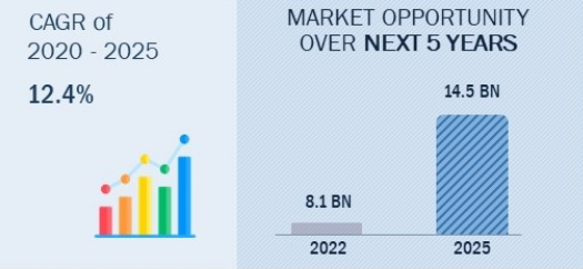
Graph showing market opportunity of global GIS to grow from 8.1 BN in 2022 to 14.5 BN in 2025, a 12.4% increase.

Source: Markets and Markets

In this article, we’ll review what geospatial data is, how spatial analysis works, and why this data is critical for business. Whether you’re looking to optimize site selection, improve real-time marketing strategies, or enhance customer engagement, geospatial insights are the key to success.

What is Geospatial Data?

Geospatial data refers to information tied to a specific location on the earth’s surface. This data comes in various formats and is crucial for gaining insights about locations. Understanding the spatial relationships between different places allows you to make more informed decisions.

By linking geographic locations to real-world data points, geospatial data helps you visualize trends effectively with the help of data visualization tools.

Key Components:

1) Spatial Data:

This component represents the physical location of a place, defined by precise geographic coordinates such as latitude and longitude. These coordinates enable the accurate pinpointing of locations on Earth, making spatial data essential for location analysis.

For example, point clouds, polygons, and vector data are common spatial elements used to define the boundaries of a geographic area, whether it’s a business, landmark, or other point of interest. Additionally, raster data represents information in a grid format with pixels, often used in satellite imagery for analysis. 

2) Attribute Data:

While spatial data answers the “where?” question, attribute data provides additional details by addressing the “what?” of a location. This includes important information such as the type of business, address, and operating hours.

For businesses utilizing Point-of-Interest (POI) data from providers like dataplor, attribute data offers essential context for making informed decisions about site selection and location optimization. Here are some examples of how geospatial data is used across various industries.

Examples of Geospatial Data:

Geospatial data is widely used across industries to support operations and strategy. Here are a few examples:

  • Point-of-Interest (POI) data: This type of geospatial data is essential if you’re aiming to gather insights about locations such as stores, restaurants, offices, and more. For instance, dataplor’s comprehensive POI data allows you to analyze the demographics and real-time updates of business locations, helping you optimize your operations.
  • Satellite Imagery: Used for a range of applications, from urban planning to environmental monitoring, satellite imagery gives you a bird’s eye view of large geographic areas. It is often processed using GIS data and tools like ArcGIS for detailed analysis.

What is Spatial Analysis?

Spatial analysis is the process of examining, interpreting, and extracting actionable insights from geospatial data. By leveraging location data and advanced algorithms, you can uncover hidden patterns, trends, and relationships that may not be apparent in traditional datasets. 

This approach allows you to make more informed decisions based on spatial relationships, enhancing everything from market analysis to customer targeting.

How does it work?

Spatial analysis leverages geospatial data to assess the relationships between various geographic points. By utilizing Geographic Information Systems (GIS) software such as ArcGIS and other analytical tools, you can perform detailed examinations of locations, analyze spatial relationships, and extract valuable insights to support decision-making.

Whether you’re examining land usage patterns or assessing the proximity of competitors, spatial analysis serves as a powerful tool for optimizing your business operations. Data collected through APIs and data sources like ESRI can support these analyses, providing the insights needed to support your strategies.

Here are some examples of spatial analysis techniques:

1. Hot Spot Analysis:

This technique allows you to identify areas with a high concentration of specific types of geospatial data. For example, if you’re looking to find optimal locations for new stores or distribution centers, you can use hot spot analysis to determine which geographic location offers the most promising opportunities.

Many businesses, like Walmart, use big data combined with geospatial information to identify these patterns.

2. Proximity Analysis:

This method evaluates the distance between different POIs, helping you understand your location in relation to your competitors. You can, for example, use proximity analysis to assess how close your store is to your suppliers or potential partners, ensuring that its location is strategically advantageous. 

Why is Geospatial Data Important for Businesses?

As businesses increasingly rely on data-driven strategies, geospatial data has become a vital resource for gaining a competitive edge. Recognizing how physical locations and their surrounding environments impact your business operations can result in more informed decision-making and better resource allocation. 

Whether you’re refining your real estate strategy or optimizing supply chain logistics, geospatial data plays an essential role in today’s data management and decision-making landscape.

Make Data-Driven Decisions

In today’s competitive business landscape, making decisions based on reliable, actionable data is essential for success. Geospatial data empowers businesses to make data-driven decisions by providing valuable location insights that enhance strategic planning, resource allocation, and operational efficiency.

For example, geospatial data analysis can assess potential sites for new retail or office locations by evaluating nearby infrastructure, competitor presence, and customer demographics. By analyzing both spatial and attribute data, businesses can optimize site selection, reduce risks, and maximize return on investment.

In industries like commercial real estate, integrating geospatial technology enables professionals to make informed decisions in investment research, risk assessment, and market and competitor analysis. These decisions are supported by precise geographic data, ensuring a comprehensive understanding of the operational landscape.

With tools like GIS software, you can visualize geographic data, making it easier to interpret complex data models and make informed decisions in real-time. Research shows that geospatial technology is widely used in urban planning and resource management to support smarter decision-making.

Improved Market Analysis and Site Selection

By utilizing POI data, Starbucks has refined its store placement strategy by targeting urban and suburban areas with high customer potential. Through geospatial data analysis, they were able to pinpoint areas with the greatest opportunity and gain a deeper understanding of their customers. Enriching their data ultimately helped them expand to over 60 countries with approximately 19,767 company-operated and licensed locations.

By targeting high-traffic and high-visibility areas, Starbucks has optimized its global reach and solidified its dominance in the coffeehouse industry. It currently holds a 36.7% market share in the U.S. coffeehouse market, depicting the effectiveness of its geospatial data-driven site selection strategy.

Enhancing Property Insurance With Geospatial Data

Tensorflight, a leader in property analytics for the insurance sector, partnered with dataplor to improve the accuracy of data used in property insurance assessments. By leveraging our POI data, they were able to improve geocoding accuracy, which allowed them to generate more accurate building replacement cost estimates and better classify building occupancy types.

These advancements have empowered Tensorflight to provide more reliable and actionable data to their insurance clients, transforming how real estate and property insurance decisions are made.

Unlock the Power of Location Data with Dataplor

In today’s competitive landscape, leveraging geospatial data and spatial analysis empowers you to make informed decisions, improve operational efficiency, and enhance customer engagement. Whether optimizing market strategies, refining site selection, or tailoring your marketing campaigns, geospatial data helps you understand the key geographic elements that drive success.

With dataplor’s Point-of-Interest (POI) data, you can gain the insights needed to make smarter location-based decisions. Learn how dataplor’s comprehensive data helped companies like Wolt and FLO® to transform their business. Request a sample today and experience the powerful benefits firsthand.

Unlock the power of location intelligence and position your business for success with our advanced geospatial data solutions. 

Get the full story

Subscribe for the latest on location intelligence, places data, and the trends behind better business decisions.

Subscribe


How Location Intelligence Transforms Business Strategy

Blog

How Location Intelligence Transforms Business Strategy

Geoff Michener
 Jan 30, 2026  •  3 min read

Technology is transforming the way companies are growing, especially through the use of location intelligence. At Dataplor, we empower many of the world’s largest companies by delivering real-time, accurate location data. This valuable geographic information can be used to fuel advanced technologies and data systems across a number of industries.

By integrating diverse data sources into their business intelligence systems, companies can elevate their location analytics and data visualization capabilities. This enriched business data enables more effective marketing campaigns and resource optimization, ultimately leading to better decisions across the board.

What is Location Intelligence?

Location intelligence is gained by analyzing geospatial data collected from various sources like GIS, satellite imaging, drones, census reports, and more. While this process can be time-consuming and complex, Dataplor simplifies it by streamlining the data collection and delivering relevant point-of-interest data directly to your business. With this information in hand, your data analysis team can easily identify marketing and retail opportunities as well as new possibilities across various industries.

How Location Intelligence Works

Location intelligence is often mistaken for simple GPS tracking, but true location intelligence is far more powerful. Rather than relying on a single data source, it uses a layer-by-layer approach to reveal how people interact with the physical world.

At its foundation is raw geospatial data, which provides precise information about where places and movement exist in space. This data is then enriched with additional layers, such as demographic insights, point of interest (POI) data, and foot traffic patterns, to add critical context. When these layers are combined, businesses can move beyond static maps and begin to understand real-world behavior.

By analyzing these interconnected datasets together, location intelligence transforms location data into actionable insights that support smarter planning, forecasting, and decision-making.

The Benefits of Location Intelligence for Businesses

Location intelligence helps businesses reduce risk, uncover growth opportunities, and make data-driven decisions with confidence. Its strategic value spans site planning, marketing, operations, and competitive analysis.

Precision Site Selection

Reduce the risk of brick-and-mortar investments by identifying locations with strong foot traffic and the right target demographic. Location intelligence replaces guesswork with real-world behavioral data to support smarter expansion decisions.

Enhanced Customer Understanding

Go beyond basic demographics to understand how customers move through and interact with physical spaces. These insights reveal behavioral patterns, preferences, and opportunities that traditional data sources often miss.

Operational Efficiency & Logistics

Improve supply chain planning and delivery efficiency by analyzing real-world movement patterns, traffic conditions, and environmental factors. Location intelligence helps streamline operations while reducing costs and delays.

Hyper-Local Marketing

Increase marketing effectiveness by tailoring campaigns to the unique behaviors and needs of specific neighborhoods. Hyper-local insights enable more relevant messaging, higher engagement, and improved conversion rates.

Competitive Benchmarking

Monitor competitor foot traffic and market share trends to understand performance in real time. These insights help businesses identify threats, measure impact, and capture new opportunities faster.

Common Use Cases of Location Intelligence Solutions

Location data holds the key to unlocking smarter business strategies across various sectors, including retail, healthcare, real estate, insurance, and more. This data-driven approach facilitates informed decision-making and maximizes revenue through several use cases:

  • Mapping: Location intelligence enables GIS and other spatial data technologies to create intuitive dashboards and visualizations, helping to identify patterns and potential relationships within and between locations.
  • Site Selection: Insights from geographic data allow organizations to assess the pros and cons of potential real estate locations, optimizing their site selection for competitive advantage.
  • Competitor Investigation: Gain a deep understanding of the competition to identify market opportunities and areas to target.
  • Supply Chain Optimization: Use location data to optimize logistics, distribution, and inventory management.
  • Risk Assessment: Identify potential risks by considering factors like ROI forecasting and fraud prevention.
  • Customer Segmentation: Customize product promotions and offerings tailored to consumer demand based on location data. 
  • Real Estate Valuation: Determine property values based on location-specific factors like proximity to amenities, schools, and transportation.
  • Urban Planning: Forecast which areas are most likely to see substantial growth, and predict the best areas for development.

Comprehensive Location Insights From Dataplor

As a leading provider of global location intelligence, Dataplor utilizes advanced machine learning, image recognition, and artificial intelligence technologies to examine vast arrays of data across more than 250 million locations in over 200 countries and territories. This commitment to quality ensures that you can make well-informed, data-driven business decisions. Our international team of analysts and human validators leverage their local experience and language fluency to maintain high data accuracy, reduce errors, and identify duplicates in real-time.

Reach Out to Our Experts for More Information

Partner with a provider committed to giving you a competitive edge. Dataplor is your global partner in location intelligence, helping your business optimize customer experiences, improve supply chain functionality, and enhance financial services through our accurate Point-of-Interest (POI) data. Our industry-leading quality control procedures ensure you receive highly accurate and relevant location data that you can trust. Contact our experts to learn how our data can strengthen your business strategy and support data science initiatives, urban planning, CRM, IoT applications, pricing strategies, and more.

Get the full story

Subscribe for the latest on location intelligence, places data, and the trends behind better business decisions.

Subscribe

Building Smarter, Safer Cities: Leveraging Location Intelligence Data

Blog

Building Smarter, Safer Cities: Leveraging Location Intelligence Data

Geoff Michener
 Jan 30, 2026  •  6 min read

Key Takeaways

  • Location intelligence helps cities understand real-time movement, optimize services, and make data-driven decisions.
  • Urban planners use geospatial insights to reduce congestion, improve emergency response, and allocate resources effectively.
  • Combined with other datasets (like census or weather data), location intelligence offers a full picture of urban dynamics.
  • Real-world examples include smarter transit in London, infrastructure planning in NYC, and population forecasting in Dubai.
  • Choosing the right data provider, like dataplor ensures accuracy, privacy compliance, and actionable insights.

Imagine a city that understands, adapts, and responds to its inhabitants’ needs with precision. 

No longer a futuristic concept, location intelligence has become the heart of modern urban development, offering unprecedented insights into the complex dynamics of city life.

Cities are more than just collections of buildings and roads. They’re living ecosystems of human movement, infrastructure, and interconnected systems. According to the United Nations, 68% of the world’s population is projected to live in urban areas by 2050, making the need for intelligent, data-driven urban management more critical than ever.

In this comprehensive guide, we’ll explore how location intelligence data is revolutionizing urban planning, public safety, and city management, providing a roadmap for creating smarter, more responsive urban environments.

What is Location Intelligence Data for Urban Environments?

Urban areas are constantly evolving landscapes shaped by human movement, infrastructure, and environmental factors. Location intelligence data provides a structured way to analyze these dynamics, offering city planners and policymakers a comprehensive view of how people interact with urban spaces. 

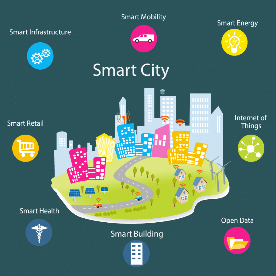
Diagram of Smart City made up of smart infrastructure, mobility, energy, IoT, open data, and more.

Source: MOCA Platform

By integrating geospatial data, real-time location analytics, and location-based insights, cities can make data-driven decisions that enhance efficiency and safety.

Location Intelligence Use Cases for Urban Planning

At its core, location intelligence leverages a mix of advanced analytics, artificial intelligence, advanced data science, and geospatial datasets. City officials can use location intelligence to:

  • Identify high-traffic areas and congestion points: Foot traffic data patterns reveal bottlenecks in transportation networks, aiding in decongestion strategies.
  • Understand population movement during emergencies: Spatial data combined with real-time analytics helps optimize evacuation plans and emergency response times by analyzing visitation patterns in highly congested areas.
  • Optimize resource allocation for public services: By integrating location data with business intelligence, cities can deploy resources like police, medical assistance, and transit where they are needed most.
  • Identify areas with higher risk of incidents: Geospatial datasets combined with crime statistics allow law enforcement to focus efforts on high-risk zones.

While location intelligence provides key insights, its value increases when combined with other business data, such as census bureau statistics, economic indicators, and even weather data for disaster preparedness. 

By integrating these diverse data sources, cities can dive deeper into urban challenges and proactively develop smarter, safer environments.

How Location Intelligence Data Enhances City Planning

Urban infrastructure development is no longer a game of educated guesses but a precise science driven by data-driven decision-making. 

With location intelligence, urban planners can move beyond broad estimations and base decisions on real-time insights about how people interact with their environment. 

Whether it’s optimizing public transit, planning new urban infrastructure, or guiding economic development, location intelligence ensures that urban growth is strategic, efficient, and sustainable.

Smart Resource Allocation for Public Services

Beyond infrastructure, public services such as schools, hospitals, and parks must be strategically placed for maximum accessibility. Location intelligence, when combined with additional city planning data, enables:

  • School and healthcare facility planning: Cities can predict future demand for schools and hospitals based on existing infrastructure and frequently visited areas..
  • Emergency services optimization: Analyzing point of interest and mobility data ensures emergency facilities like fire stations and ambulances are placed in high-need areas.
  • Green space development: Location intelligence helps planners identify areas lacking parks and recreational spaces, promoting balanced urban development.

Zoning and Land Use Optimization

Land use decisions impact everything from residential density to commercial zoning. Geospatial insights enable planners to:

  • Determine optimal zoning regulations: Balancing residential, commercial, and industrial spaces to promote efficient urban growth.
  • Prevent overdevelopment and urban sprawl: Identifying areas that require preservation or controlled expansion.
  • Assess environmental impact: By overlaying air quality measures with location and mobility data, policymakers can prioritize interventions where vulnerable populations are most affected (like schools or hospitals).

Economic Development Strategies

A city’s economic success depends on understanding market trends and consumer behavior. Location intelligence supports:

  • Site selection for businesses: Analyzing customer movement patterns to identify prime retail locations and boost customer relationship management. 
  • Competitive market analysis: Mapping existing businesses to determine gaps in service and potential investment areas.
  • Tourism and event planning: Understanding visitor trends to strategically place attractions and facilities.

Other Real-World Location Intelligence Use Cases

  • Public transportation optimization: Cities like Singapore and London use real-time location data to adjust bus and metro frequencies, ensuring efficient commuter flow.
  • Infrastructure investment: Road maintenance and expansion projects in New York City are prioritized based on traffic congestion data and wear analysis.
  • Population growth planning: Fast-growing cities like Dubai and Austin use geospatial analytics to plan new residential zones, schools, and hospitals.
  • Impact assessment of urban development projects: Location intelligence tools help evaluate the effects of large-scale developments like stadiums, shopping centers, or new highways, ensuring they benefit the community.

Choosing a Location Intelligence Data Provider

With public safety relying on accurate and timely location intelligence, selecting the right data provider is crucial. 

Here are the evaluation criteria to consider: 

  • Data accuracy and reliability: Consistently updated and verified datasets to ensure and provide insights
  • Global coverage and geographic reach: Supporting cross-jurisdictional safety planning for large metropolitan areas
  • Data privacy and compliance: Ensuring compliance with GDPR, CCPA, and other privacy regulations by using aggregated, anonymized data
  • Integration with other data sources: Compatibility with existing GIS platforms, emergency dispatch systems, and law enforcement databases.
  • Customer support and expertise: Ongoing guidance from GIS specialists

Leading location intelligence providers like dataplor offer:

  • Aggregated, anonymized data for privacy protection
  • Consistent updates to the data directory to reflect real-time global insights
  • Expertise in analyzing spatial data

The Future of Smart Cities is Location Intelligence

As urban populations continue to grow, the role of location intelligence in city planning and public safety becomes indispensable. 

Cities that embrace advanced analytics, artificial intelligence, and real-time geospatial insights will be better equipped to handle emergencies, prevent crime, and optimize resource allocation. In addition, they’ll benefit from:

  • Improved infrastructure efficiency, such as optimizing road networks, transit systems, and public safety facilities.
  • Optimized resource allocation in areas such as law enforcement, medical, and emergency resources is used where needed most.
  • More responsive urban environments by leveraging real-time data to adapt to changing urban dynamics.

Are you ready to transform your city’s potential with location intelligence? 

Explore how dataplor’s data-driven insights can revolutionize urban planning and public safety strategies. Contact us today to get started. 

Get the full story

Subscribe for the latest on location intelligence, places data, and the trends behind better business decisions.

Subscribe
Data-Driven Property Valuation: The Power of Foot Traffic Trends

Blog

Data-Driven Property Valuation: The Power of Foot Traffic Trends

Geoff Michener
 Aug 08, 2025  •  8 min read

When making commercial real estate decisions, you should go beyond just evaluating the physical location. You also need to understand the living, breathing ecosystem surrounding a property. According to the National Association of Realtors, foot traffic data has a strong link to future sales and contracts being made, making it a critical metric for investors and property developers.

Foot traffic refers to the movement of people through a specific area and has become a pivotal indicator of commercial property potential. 

By leveraging advanced mobility data and foot traffic analytics, real estate professionals can gain actionable retail foot traffic insights far beyond traditional assessment methods.

Why Foot Traffic Matters in Commercial Real Estate

Historically, property valuation relied on traditional metrics: square footage, location, and basic demographic information. Today, foot traffic software has revolutionized this approach, offering granular insights that were previously impossible to capture.

Source: dataplor

Key dimensions of foot traffic analysis include:

  • Aggregated pedestrian counts
  • Temporal trends (daily, weekly, monthly, yearly)
  • Peak hour variations
  • Seasonal fluctuations

So, how does this impact CRE? The correlation between how you count foot traffic and property value is valuable:

  • High foot traffic indicates a higher business potential
  • Consistent pedestrian movement suggests economic stability
  • Traffic fluctuations can reveal emerging market shifts
  • Visitor behavior provides insights into local economic health

How Foot Traffic Enhances Property Valuation

Foot traffic insights provide a multi-dimensional view of a property’s potential. These trends help professionals assess retail business viability, evaluate location attractiveness, identify high-potential customer bases, and understand seasonal and event-driven variations.

Location data can help retail store managers: 

  • Identify peak hours of customer engagement
  • Understand customer dwell times
  • Analyze conversion rates
  • Optimize retail store design and layout

For realtors and commercial property valuation, foot traffic counts can help: 

  • Assess potential rental income
  • Evaluate location attractiveness
  • Predict future property value trends
  • Compare different property locations objectively

Within marketing and business strategy, foot traffic data can help: 

  • Design targeted advertising and marketing campaigns
  • Understand customer demographics
  • Optimize staffing levels
  • Identify potential business expansion opportunities

For instance, a retail location with consistent foot traffic during peak hours might command a premium, while an area showing growth in visitor behavior could signal an emerging market opportunity.

By leveraging advanced data analytics, real estate professionals can unlock a treasure trove of insights across these areas. Check out our foot traffic data guide for further information.

Integrating Foot Traffic with Other Data Sources

Accurate property valuation requires a holistic, data-driven approach. By combining foot traffic data with complementary datasets, professionals can create a 360-degree assessment across the following areas:

  • Points of Interest (POI) Data: With foot traffic data, you can map surrounding businesses, better understand the local ecosystem, and identify complementary and competitive establishments.
  • Economic Indicators: Foot traffic data helps assess area economic health, track employment trends, and understand income distribution.
  • Market Trends: Finally, you can evaluate property sales dynamics, monitor rental market fluctuations, and identify emerging investment opportunities.

dataplor’s unique global data schema ensures that these integrated insights remain consistent and comparable across different regions.

Key Considerations When Choosing a Foot Traffic Data Provider

Selecting the right foot traffic data provider can mean the difference between making informed, strategic decisions and falling prey to incomplete or inaccurate insights.

Choosing a foot traffic data provider requires careful evaluation across multiple critical dimensions. 

The ideal provider should offer a comprehensive, reliable, and privacy-conscious approach to location intelligence that transforms raw data into actionable business insights.

Data Accuracy and Reliability 

Businesses must verify a provider’s data verification process, looking beyond surface-level collection methods. This means examining the provider’s track record of precision, understanding their approach to human verification, and assessing the frequency and rigor of data updates. 

A truly exceptional provider goes beyond algorithmic collection, incorporating human expertise to validate and refine data points.

Geographic Coverage 

The most valuable foot traffic data providers offer extensive global reach, demonstrating expertise across international markets. This goes beyond simply collecting data in multiple countries and requires a nuanced understanding of regional address formats, cultural variations, and local business landscapes. 

Providers like dataplor, which covers over 250 countries, understand that true global intelligence means maintaining a consistent data schema while respecting local complexities.

Data Privacy and Compliance 

The ideal foot traffic data provider prioritizes GDPR compliance and implements robust privacy protection mechanisms. This means instilling an industry practice of using anonymized, aggregated data that protects individual identities while still providing meaningful insights.

Reputable providers carefully filter out sensitive locations, ensure no personally identifiable information is collected in reports, and maintain transparent data collection methodologies while ensuring peak performance.

Red Flags to Watch Out For

Exercise caution with data providers who cannot transparently explain their collection methodology, lack consistency in global data, or offer unrealistically low-cost solutions. The most reliable providers demonstrate a commitment to data quality, global expertise, and privacy protection.

Ultimately, the right foot traffic data provider should feel like a strategic partner. dataplor’s location intelligence solutions offer a comprehensive approach that goes beyond simple data collection, providing actionable insights that can transform business strategy.

The Power of Foot Traffic Trends in Property Valuation

As technology advances, foot traffic trends will become increasingly sophisticated. Future developments may include:

  • More precise movement tracking
  • Enhanced predictive capabilities
  • Deeper integration with AI technologies
  • More comprehensive privacy protections
  • Real-time global insights

Ready to revolutionize your property valuation strategy? Explore our comprehensive data offerings and unlock the full potential of data-driven decision-making.

After all, location is no longer just a point on a map. It’s a dynamic, evolving ecosystem of human movement, economic potential, and market opportunity.

Get the full story

Subscribe for the latest on location intelligence, places data, and the trends behind better business decisions.

Subscribe

Geofencing Marketing: Using Location Data to Tailor Advertising

Blog

Geofencing Marketing: Using Location Data to Tailor Advertising

Geoff Michener
 Jul 08, 2025  •  7 min read

The numbers don’t lie: 86% of the global population—a staggering 6.92 billion people—now use smartphones. Americans alone spend nearly four and a half hours daily on their mobile devices. This unprecedented mobile connectivity has created fertile ground for advertisers, who are expected to spend nearly $400 billion by 2024.

At the heart of effective mobile advertising lies a critical component: location data. 

Understanding where consumers go and what they do forms the foundation of today’s most targeted mobile marketing solutions and strategies. For brands aiming to reach specific audiences globally, geofencing marketing stands out as a particularly effective strategy.

In this article, we’ll explore how geofencing marketing works, its key benefits, implementation strategies, and how high-quality location data fuels successful campaigns.

What is Geofencing Marketing? 

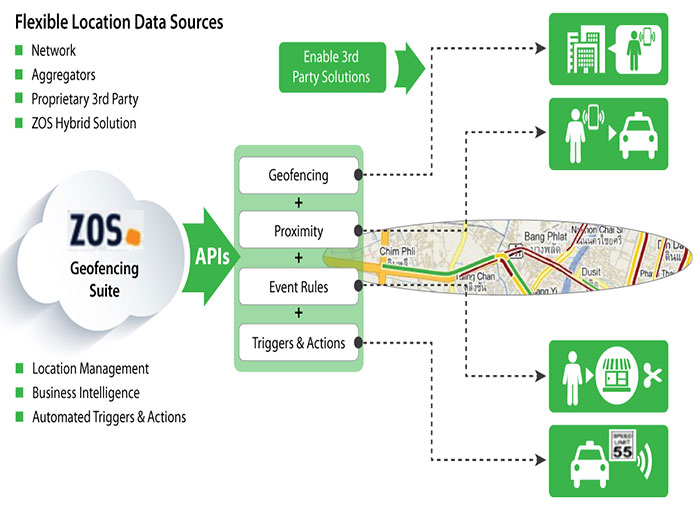
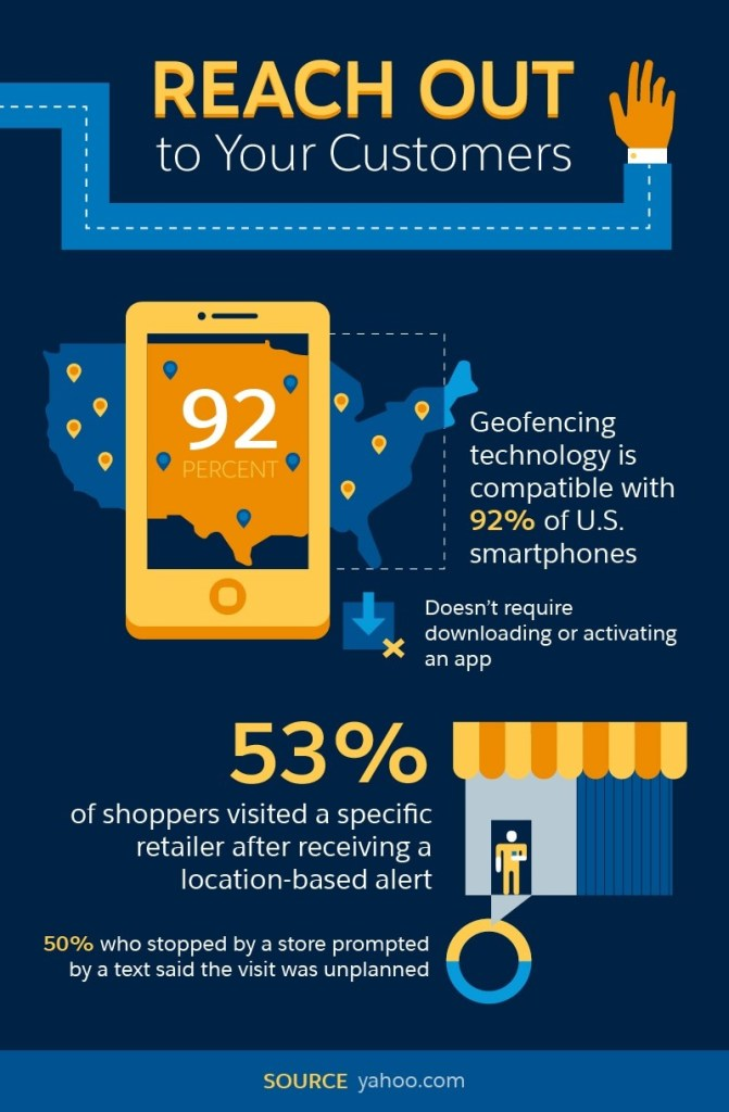
Geofencing marketing involves creating virtual boundaries around specific physical locations to trigger targeted advertising when mobile users enter those defined areas. 

Unlike broader location-based marketing approaches, geofencing creates precise digital perimeters around points of interest (POIs) such as stores, malls, or event venues.

This approach differs significantly from geotargeting, which focuses on broader areas like cities or zip codes. While geotargeting casts a wider net, mobile geofencing marketing delivers hyper-relevant messages to users at specific locations at precisely the right moment.

When a mobile device enters these virtual boundaries, it can trigger various marketing actions, from sending push notifications and SMS messages to in-app ads and social media content.

Source: Salesforce

Recent research from Factual found that 80% of consumers want location-based alerts and offers from businesses, making geofencing marketing a particularly effective way to engage potential customers. 

However, implementation requires careful attention to privacy regulations like GDPR and CCPA, which govern how location data can be collected and used.

Key Benefits of Geofencing Marketing

The strategic advantages of geofencing in your marketing efforts go far beyond basic location targeting.

Enhanced Targeting Precision

Geofencing marketing allows businesses to focus ad spend on consumers most likely to convert. 

For instance, a retail store can target shoppers making their way into a shopping mall, delivering timely promotional offers directly to their mobile devices. This precision helps optimize campaigns by reducing wasted impressions on uninterested audiences.

Improved Engagement Rates

Location-based marketing messages delivered at the right time and place see significantly higher engagement. Geofencing can boost engagement rates compared to standard mobile advertising. 

When a user receives a relevant offer while already in shopping mode, they’re much more likely to take immediate action.

Real-Time Consumer Insights

Geofencing campaigns provide valuable information about customer behavior, including foot traffic patterns, visit frequency, and dwell time. 

These insights help brands refine their marketing strategy beyond the digital realm, informing decisions about everything from store layouts to staffing levels.

Competitive Advantage Through Geo-Conquesting

One particularly powerful application is geo-conquesting—setting up geofencing ads around a competitor’s store or location. This marketing geofence approach allows businesses to intercept potential customers at critical decision-making moments. 

For example, a quick-service restaurant might offer a special discount to mobile users near a competitor’s location, potentially diverting that traffic to their own establishment.

Measurable ROI

Unlike traditional advertising technology and methods, geofencing marketing campaigns deliver highly trackable results. 

Marketers can measure key metrics like ad impressions, store visits, and conversion rates with precision, helping to show a clear idea of the return on advertising investments.

Geofencing Marketing Strategies and Best Practices

Building effective geofencing advertising requires thoughtful planning and execution. Here are key strategies for success.

  • Define Clear Objectives: Before launching a geofencing campaign, establish specific goals. Are you looking to drive foot traffic to a retail store? Increase sales of certain products? Counter a competitor’s promotion? Your objectives will shape everything from fence placement to messaging strategy.
  • Select Strategic Locations: Not all locations deserve equal attention in your geofencing marketing work. Focus on areas with high foot traffic that are relevant to your target audience. A luxury retailer might fence high-end shopping districts, while a casual dining restaurant might target office complexes during lunch hours or entertainment venues before and after events.
  • Craft Compelling, Location-Relevant Messages: The most effective geofencing ads acknowledge location context. Generic marketing messages waste the opportunity that location targeting provides. For example, a coffee shop might send different push notifications to users passing by in the morning (”Start your day with our breakfast special”) versus in the afternoon (”Need an afternoon pick-me-up?”).
  • Combine With Other Marketing Channels: Integrate geofencing with your broader marketing efforts for maximum impact. Location data can enhance email campaigns, direct mail campaigns, social media advertising, and even political campaigns by adding geographical context to audience targeting.
  • Respect Privacy and Preferences: With growing concerns about data privacy, transparent practices are essential. Always obtain proper consent for location services, provide clear opt-out mechanisms, and adhere to relevant regulations. Respecting user privacy builds trust and prevents potential backlash.
  • Test and Optimize: Successful geofencing marketing involves continuous refinement. A/B test different message formats, fence sizes, timing, and offers. Track which approaches drive the strongest response, then adjust your strategy accordingly.

dataplor’s POI Data: Fueling Effective Geofencing Campaigns

The effectiveness of any geofencing advertising campaign hinges on data quality. 

Inaccurate location data can lead to misplaced fences, irrelevant targeting, and wasted ad spend, which can be particularly problematic when expanding into international markets.

dataplor provides the foundation for successful global geofencing with the following features.

Accurate and Comprehensive POI Data

dataplor offers meticulously verified point of interest data covering over 250 countries and territories. 

This global positioning system of business locations includes detailed attributes like addresses, operating hours, and category classifications, all essential information for creating relevant geofencing triggers.

Real-Time Updates

Business landscapes change constantly. Stores close, new establishments open, and operating hours shift. 

dataplor’s data undergoes continuous updating and verification, ensuring that mobile advertising campaigns don’t target defunct locations, which is a common problem with open-source data alternatives.

International Expertise

For brands expanding globally, dataplor provides uniquely valuable international coverage with consistent data schema across regions. 

This uniformity simplifies the process of implementing geofencing across different markets, allowing for truly global campaigns without sacrificing local relevance.

Advanced Mapping

Unlike basic radius-based geofencing tools, dataplor offers precise, advanced mapping of locations. 

This approach allows marketers to define virtual boundaries that match building footprints, significantly improving targeting accuracy and reducing overlap between nearby locations.

Geofencing: Where Location Meets Strategy

Geofencing marketing represents the intersection of physical location and digital strategy, a powerful convergence reshaping how brands connect with mobile users. 

As location-based technologies evolve, geofencing capabilities will only become more sophisticated, incorporating beacon technology, augmented reality, and deeper integration with mobile apps.

Forward-thinking marketers who recognize that geofencing isn’t merely a tactic but a fundamental shift in how brands can create contextually relevant experiences will gain significant advantages in today’s competitive landscape, but only when built on reliable data.

As mobile device usage continues its upward trajectory, the brands that thrive will be those that communicate with consumers at the right place and time with personalized messages that respect privacy while delivering genuine value.

Don’t miss out! If you’re ready to transform your location-based marketing efforts, the first step is securing accurate, comprehensive location data. 

dataplor’s globally verified POI database provides the foundation for building geofencing campaigns that genuinely connect with customers—wherever they may be.

Ready to explore how dataplor’s location intelligence can power your next geofencing marketing campaign? Contact our team today to learn more about our customized data solutions.

Get the full story

Subscribe for the latest on location intelligence, places data, and the trends behind better business decisions.

Subscribe

Geofencing Data: A Strategic Asset for Modern Business

Blog

Geofencing Data: A Strategic Asset for Modern Business

Geoff Michener
 Jun 24, 2025  •  9 min read

Have you ever walked into a store and received a perfectly timed discount notification on your phone? Or perhaps wondered how businesses seem to know exactly when you’re near their locations? 

The intersection of the physical and digital realms has created powerful new ways for businesses to connect with consumers, but what’s really happening behind the scenes?

Today’s most innovative enterprises are quietly revolutionizing how they engage customers by tapping into one of the most underutilized data assets available: the precise geographic locations where people spend their time. 

As mobile devices become extensions of ourselves, the data generated from our movements creates unprecedented opportunities for businesses to understand and respond to customer behavior in real-time.

At the core of this revolution is geofencing data. This is any information generated when users cross virtual boundaries established around physical locations. This powerful dataset is transforming how businesses make strategic decisions across industries, from retail to real estate, logistics to finance.

In this article, we will review what geofencing data is, how it works, and most importantly, how forward-thinking organizations like yours can partner with dataplor and use it to gain a competitive advantage in an increasingly location-aware marketplace.

Geofencing Data: What It Is and How It Works 

Think of geofencing as setting digital tripwires around real-world places such as your storefront, a rival’s location, or even a busy commercial hub. When someone enters or exits these zones, it triggers a flow of actionable data. That’s the core power of geofencing technology.

Geofencing data is created when a mobile device’s location enters or exits a predefined virtual boundary established around a physical location. These virtual fences typically rely on Global Positioning System (GPS) technology, cellular data networks, Wi-Fi signals, or radio frequency identification (RFID) to detect when a device crosses the established perimeter.

The resulting dataset doesn’t identify specific individuals but instead reveals patterns like:

  • How many devices entered a location
  • How long they stayed
  • What time of day saw peak activity
  • How these patterns change over time

For example, a retail chain might establish geofences around all store locations to understand foot traffic patterns before and after a major marketing campaign.

In fact, businesses using geofencing see a doubled engagement rate compared to standard mobile targeting methods.

What makes geofencing work effectively is its ability to trigger actions based on location context. When a device enters or exits a virtual boundary, geofencing software can automatically collect anonymized data about that movement, providing businesses with valuable insights about location-based behavior while maintaining user privacy.

Strategic Applications of Geofencing Data Across Industries

Wondering how geofencing data makes an impact in different industries? Here’s what you need to know.

Retail and Marketing

The retail sector has emerged as one of the primary beneficiaries of geofencing technology. By understanding how customers move around and between physical locations, retailers can refine their targeted marketing strategy and optimize operations.

Location-based marketing becomes dramatically more effective when informed by geofencing data. Rather than blanketing an entire region with generic advertisements, businesses can deliver targeted advertising and messaging to mobile users based on their geographical location and specific movement patterns. 

For instance, a coffee shop might analyze patterns of devices that regularly visit competitor locations, then tailor specific offers to those potential customers.

Source: Salesforce

In-app and push notifications triggered by geofencing capabilities allow brands to engage customers at the most receptive moments, when they’re physically near a retail store or have just entered a shopping district. 80% of consumers want location-based alerts and are willing to share location data in exchange for relevant offers.

Sophisticated retailers are now using geofencing statistics to understand the relationship between external events and store visits, measuring how weather patterns, local sports events, or even traffic disruptions impact customer flow.

Real Estate and Urban Planning

For real estate developers and urban planners, understanding how the local population moves through space is invaluable. Geofencing data provides insights into which areas receive high foot traffic, when people visit different districts, and how long they typically stay.

By establishing virtual boundaries around different neighborhoods, developers can quantify movement patterns and identify emerging hotspots before they become obvious to competitors. This gives early movers a significant advantage in site selection and property acquisition.

Real estate investors are increasingly integrating geofencing data into their analysis frameworks, using foot traffic as a leading indicator of area desirability and economic vitality. For example, a neighborhood showing increasing dwell time and visit frequency often signals rising property values.

Logistics and Operations

The logistics sector has embraced geofencing solutions for both fleet management and asset management. By defining virtual boundaries around warehouses, distribution centers, and delivery zones, companies gain unprecedented visibility into their operations.

Source: Happiest Minds

When a delivery vehicle enters or exits a designated area, geofencing software can automatically log arrival and departure times, eliminating manual check-ins and improving data collection accuracy. This creates a wealth of information for optimizing routes and schedules.

For CPG companies, understanding how products move through distribution networks and into retail environments is critical. Geofencing relies on location tracking to provide visibility into this journey, helping brands ensure optimal product placement and availability.

Beyond traditional logistics, drone management has emerged as a cutting-edge application of geofencing technology. By establishing no-fly zones and operational boundaries, drone operators can automate compliance with regulations and optimize flight paths.

Finance and Risk Management

Financial institutions are harnessing geofencing capabilities to enhance security and deliver more personalized location services. When customers enter branch locations, sophisticated systems can analyze traffic patterns to optimize staffing and service delivery.

Risk assessment benefits from location data by identifying unusual patterns that might indicate fraud. For example, if a customer’s device enters or exits locations in a pattern inconsistent with their established behavior, additional verification might be triggered.

Investment firms analyze geofencing data to evaluate retail performance, feeding location-based insights into their valuation models. Understanding customer engagement at specific locations provides a competitive advantage when making investment decisions.

Key Considerations for Leveraging Geofencing Data

Before you begin to use geofencing data, you need to keep these key factors in mind.

Defining Clear Objectives

Before implementing geofencing as part of your business strategy, clearly articulate what you hope to achieve. 

  • Are you looking to enhance customer engagement? 
  • Improve operational efficiency? 
  • Gain competitive intelligence? 

The specific goals will determine which aspects of geofencing data are most valuable to your organization.

For location-based triggers to deliver value, they must connect to specific business outcomes. Random data collection without a clear purpose rarely yields actionable insights.

Data Accuracy and Reliability

The effectiveness of any geofencing campaign depends entirely on the accuracy of the underlying data. Location accuracy can vary significantly based on the technology used (GPS vs. cellular geofencing) and environmental factors.

High-quality geofencing data requires precise latitude and longitude coordinates for each location, consistent monitoring of when a device enters or exits boundaries, and reliable processing of this information. 

Working with experienced providers like dataplor who specialize in location-based services is essential for meaningful results.

Privacy and Compliance

Consumer privacy must remain paramount when working with location data. Ensure all geofencing work complies with relevant regulations like GDPR and CCPA, focusing on anonymized, aggregated data rather than tracking specific individuals.

The most sustainable approach is to focus on patterns and trends rather than individual user behavior. This not only respects privacy but often yields more strategically valuable insights anyway.

Integration with Other Data Sources

Geofencing data becomes exponentially more valuable when combined with other business intelligence. Integrating location-based insights with customer profiles, transaction histories, and external factors like weather or local events creates a comprehensive understanding of the factors influencing customer decisions.

The messaging effectiveness of location-based marketing improves dramatically when informed by a holistic view of customer context and preferences.

The Synergistic Power of Geofencing Data and POI Data

While geofencing technology provides information about when and how many people visit locations, Point of Interest (POI) data tells you precisely what exists at each location. When combined, these datasets create an unparalleled view of the relationship between places and people.

Consider these scenarios:

  • A quick-service restaurant chain planning expansion might use POI data to reveal competitor density in various neighborhoods, while geofencing data shows actual foot traffic to those locations. Together, they paint a complete picture of market opportunity.
  • For retail businesses, understanding the correlation between specific store attributes (identified through POI data) and customer visits (measured through geofencing) enables more strategic decision-making about store design, merchandising, and marketing efforts.
  • Mobile apps that leverage both datasets can deliver highly personalized experiences, sending trigger notifications that are contextually relevant to both the user’s location and the specific characteristics of nearby businesses.
  • Media companies can optimize targeted advertisements by understanding both where audiences spend time and what specific businesses or amenities exist in those areas. This allows for more relevant social media ads and mobile ads that connect with consumers at precisely the right moment.

Harness Location Intelligence for Strategic Advantage

The businesses gaining the greatest advantage from geofencing data are those that view it as a long-term strategic asset and a fundamental source of insight that informs decision-making across the organization.

By decoding how people move through the physical world, companies can bridge the online/offline divide and deliver customer experiences that feel seamless, timely, and relevant. Active geofences don’t just track—they reveal patterns, unlock efficiencies, and spark innovation.

As location-based technology becomes more advanced, the winners will be those who build real fluency in geospatial data—collecting it with precision, analyzing it with intent, and acting on it with clarity.

Want to turn location data into a strategic advantage?

Reach out to dataplor today to explore our global, privacy-compliant geofencing and POI solutions. We’ll help you unlock powerful insights and stay ahead in an increasingly location-aware world.

Get the full story

Subscribe for the latest on location intelligence, places data, and the trends behind better business decisions.

Subscribe

Announcing Our $20.5M Series B to Expand Global Location Intelligence and Meet Growing Demand for Smarter, Compliant Data

Blog

Announcing Our $20.5M Series B to Expand Global Location Intelligence and Meet Growing Demand for Smarter, Compliant Data

Geoff Michener
 Jun 03, 2025  •  7 min read

Today marks another major step forward in dataplor’s mission to build the world’s most accurate, complete, and comprehensive source of global location intelligence. We’ve successfully closed our $20.5 million Series B funding round, led by F-Prime with participation from Spark Capital, FFVC, Acronym Venture Capital, Space Capital, Two Lanterns, APA Ventures, dara5, and Alumni Ventures.

This new round will accelerate our growth at a critical time, following the launch of our global mobility product and amid a surge in demand for location data that works globally, not just in the U.S.

While the world has become more connected, the data that powers global business hasn’t kept pace. In many international markets, location data remains difficult to access, riddled with inaccuracies, and often sourced from outdated or unverified platforms. Most providers concentrate on the U.S. and Canada, leaving major coverage gaps in high-growth and underserved regions. As a result, businesses are often forced to rely on static data that hasn’t been updated in years. The consequences? Flawed market assessments, inefficient resource allocation, and critical decisions made without a clear view of the ground.

At dataplor, we built our platform to solve this exact problem: delivering globally scaled, locally verified data that reflects the real world as it is today. As the only single-vendor solution for global location intelligence, dataplor eliminates the need to cobble together messy, inconsistent datasets, providing clean, deduped, and normalized data from one trusted source.

Scaling the Infrastructure for Smarter Global Decisions

With this new funding, we’re doubling down on what makes dataplor unique: a globally scaled and locally verified approach that blends proprietary AI, machine learning, and native-language human review to deliver dynamic, near-real-time, privacy-first location intelligence, even in the most data-scarce regions.

Our proprietary data now covers over 370 million Points of Interest (POIs) across more than 250 countries and territories, with mobility insights layered on top to show how consumers behave and move across spaces. We’ve also expanded our privacy-compliant foot traffic product internationally, giving customers fresh, actionable insights without ever exposing personally identifiable information (PII).

This funding enables us to:

  • Expand geographic coverage in under-mapped markets
  • Enhance our POI and mobility product suite
  • Support more seamless customer integrations
  • Invest in new talent and technology to further scale our infrastructure

How Our Customers Use dataplor

Our customers are global businesses solving complex challenges. They rely on dataplor to power decisions across operations, growth, and risk modeling:

  • Financial services and insurance providers use our POI data to assess property risk and exposure at the building level
  • Retail and CPG leaders tap into our intelligence to find new partners, identify white space, and guide market expansion
  • Logistics and EV infrastructure companies use our mobility data to forecast demand and optimize location strategies

And they do so with confidence, knowing our data is accurate, complete, and fully compliant with international privacy standards.

The Road Ahead

What sets dataplor apart isn’t just our tech stack, it’s our team and principles. We’ve built a system that respects privacy, scales globally, and delivers real-world business impact. We don’t track individuals. We don’t scrape data indiscriminately. Instead, we’ve created a new standard for POI and mobility intelligence, one that prioritizes ethics, quality, and transparency.

I’m deeply grateful to our investors, new and existing, for recognizing the importance of this mission. Their support helps us move faster, think bigger, and deliver more value to our customers worldwide.

And none of this would be possible without the incredible team behind dataplor. From engineers and analysts to customer success and operations, this group shows up every day with the precision, care, and curiosity needed to solve some of the hardest data challenges on the planet. I’m proud to build alongside them.

As we scale our platform, our focus remains the same: to build the most accurate, privacy-first location intelligence platform in the world. Our customers deserve better data, and the global market depends on it.

We’re proud of how far we’ve come, but even more excited about what’s next. If your team is navigating global growth, expansion, or risk modeling and needs location data you can trust, we’re here to help.

Let’s build the future of location intelligence together.

Get the full story

Subscribe for the latest on location intelligence, places data, and the trends behind better business decisions.

Subscribe
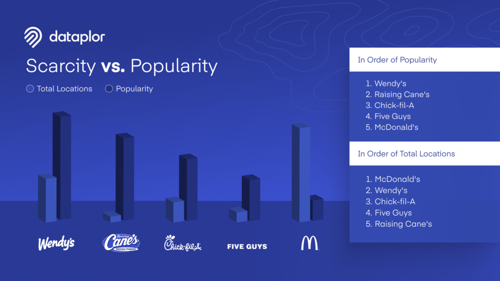
Introducing dataplor’s Global Mobility Data: Foot Traffic Insights at Scale

Blog

Introducing dataplor’s Global Mobility Data: Foot Traffic Insights at Scale

Geoff Michener
 May 19, 2025  •  7 min read

Foot traffic data is no longer just a North American product, it’s a global imperative. As businesses expand into new markets and adapt to shifting consumer behaviors worldwide, the need for precise, GDPR-compliant, privacy-first mobility data has never been more urgent.

To meet this demand, dataplor is expanding its mobility product globally, bringing timely, POI-level foot traffic insights to countries around the world. From major retail hubs to high-growth emerging markets, companies can now access the same caliber of mobility intelligence internationally that they’ve come to rely on in the U.S., Canada, and Mexico.

What is Global Mobility Data and Why Now?

Mobility data, also known as foot traffic data, measures when and how many people visit a specific place. Combined with dataplor’s point-of-interest (POI) data, this reveals where consumers go, how often, when, and in what context. For multinational businesses, this type of intelligence is foundational to making strategic decisions around expansion, marketing, investment, and operations.

Global enterprises have long grappled with fragmented and incomplete location intelligence solutions, with many providers offering only partial visibility or overlooking emerging markets entirely. Even when data is available, it often lacks the precision needed to tie foot traffic to specific points of interest, limiting its usefulness. Compounding these issues are growing privacy concerns, as many existing solutions fail to meet compliance standards like GDPR or rely on opaque data collection practices.

dataplor’s global mobility product directly addresses these gaps, offering monthly, GDPR-compliant data across both developed and underserved regions, with precise attribution down to individual POIs. What sets our solution apart is its ability to deliver:

  • Granular POI-Level Tracking: Understand exactly which store, venue, or site is being visited, not just general zones or districts.
  • Expanded Global Reach: Access mobility insights in regions that were previously underserved, including key growth markets.
  • Monthly Updates: Stay current with data that’s refreshed every month, rather than relying on outdated quarterly snapshots.
  • Privacy-First Design: Our data is anonymized, aggregated, and compliant with all relevant global privacy regulations.

Combining POI and mobility data, dataplor eliminates the need for patchwork solutions, giving global enterprises a unified, dependable source for location intelligence.

Global Applications, Real-World Impact

The use cases for mobility data are expanding, and industries worldwide can tap into dataplor’s insights to power smarter decisions:

Retailers and quick-service restaurants can pinpoint high-traffic areas, evaluate market potential, and strategically expand into new regions. Consumer packaged goods companies can optimize distribution by targeting stores with proven footfall. Tourism boards and hospitality groups can analyze visitor patterns through major attractions and travel corridors, fine-tuning everything from marketing to operations.

Meanwhile, city planners and infrastructure leaders can use real-world movement data to design more efficient, accessible urban spaces. Real estate professionals, from developers to investors, can assess property value and neighborhood potential through the lens of actual consumer activity.

The World is Moving. We’re Tracking It

As global connectivity deepens, businesses need more than static maps and quarterly reports. They need a consistent, ethical, and scalable way to understand real-world human movement, no matter the market.

Powered by anonymized mobile location signals, verified POI data, and a privacy-first foundation that meets global standards like GDPR, dataplor’s global mobility product delivers the clarity and confidence today’s businesses demand.

Whether you’re optimizing a retail footprint in Southeast Asia, tracking tourism patterns across Europe, or assessing real estate opportunities in Latin America, dataplor provides the insights to help you move forward.

Want to see what global foot traffic looks like in action? Explore our latest tourist attraction report or request a sample to get started.

Get the full story

Subscribe for the latest on location intelligence, places data, and the trends behind better business decisions.

Subscribe

Unlocking the Power of Mobility Data: Insights for Localized Strategies

Blog

Unlocking the Power of Mobility Data: Insights for Localized Strategies

Geoff Michener
 May 19, 2025  •  7 min read

What is Mobility Data?

Mobility data provides dynamic insights into visitation patterns across various locations. This data offers valuable information about how people move and interact within the physical world, enabling businesses to make informed decisions.

Unlike static location data which offers a more limited view of business attributes, mobility data reveals trends and patterns in how people visit given locations over time. By analyzing anonymized and aggregated visitation data, businesses can gain a deeper understanding of consumer behavior and make informed decisions about market analysis, site selection, and more. This data provides insights into overall movement trends without compromising individual privacy.

According to MarketsandMarkets, the location data industry is expected to reach $39.2 billion by 2025 as the demand for precise and actionable mobility data across industries grows. 

Location data providers offer valuable data that enables businesses to understand foot traffic patterns, refine location-based targeting, and make informed decisions.

In this article, we will explore the fundamentals of mobility location data, the sources of location data, and how businesses can leverage POI and mobility data to develop effective site selection and market expansion strategies. We’ll also look at how location data companies like dataplor can offer better data accuracy and reliability than unverified, publicly-available location data sources.

Why is Mobility Location Data Important?

Mobility location data forms the foundation of modern strategy for businesses that want to get real-time insights into consumer behavior, movement patterns, and local trends. 

Having accurate and up-to-date location data allows organizations to make informed decisions, adapt to changing market conditions, and create highly personalized experiences for their customers.

In today’s competitive landscape, businesses in sectors such as retail, real estate, transportation, CPG, and more are leveraging mobility data to enhance their operations. 

With localized strategies driven by this data, businesses can:

  • Allocate resources based on foot traffic patterns
  • Identify areas for expansion or investment
  • Deliver location-based advertising

Additionally, unlike static data, mobility location data enables businesses to respond to real-world changes. This means you can track how weather impacts foot traffic or assess the performance of a marketing campaign in specific locations. 

Being able to process location data in real-time allows businesses to stay one step ahead.

For example, imagine a global retail brand like H&M using mobility data to analyze customer movement during peak holiday shopping hours. With this data, H&M can allocate staff and stock to the stores with the most foot traffic. This type of real-time optimization can lead to an increase of in-store sales.

Key Use Cases of Mobility Location Data

Mobility location data is a powerful tool with a wide range of applications. Its real-time accuracy is essential for making targeted decisions, optimizing operations, and enhancing customer experiences. Below are some of the most popular use cases for mobility location data.

Business Applications

Mobility location data is transforming the way businesses operate, providing valuable insights to drive growth and improve decision-making.

Here are the industries where it’s being used most proactively:

Retail

Mobility location data gives retailers a deeper understanding of customer behavior and trends. By analyzing foot traffic patterns, businesses can identify top-performing stores, spot underperforming locations, and measure the effectiveness of marketing campaigns. 

For example, real-time location data can: 

  • Target customers with promotions as they enter specific areas
  • Enable better competitive analysis by allowing retailers to benchmark against nearby competitors
  • Inform site selection by identifying high-traffic areas for future expansion

Real Estate

In the real estate sector, mobility location data is a game-changer for demand forecasting and property valuation. 

Developers and investors can assess the desirability of a location by analyzing traffic patterns, demographic data, geospatial data, and proximity to amenities. High-traffic areas become more prominent, helping realtors pinpoint prime locations for new developments.

This data-driven approach also sheds light on how seasonal or economic changes impact different areas.

Transportation

Transportation services, from public transit to logistics companies, use mobility location data to enhance efficiency in several ways:

  • Traffic flow analysis helps identify congestion points and develop better routing 
  • Public transportation agencies can optimize schedules based on passenger patterns
  • Ride-sharing services rely heavily on this data to match supply with demand and offer dynamic pricing

Logistics and delivery companies use real-time data to improve delivery times, reduce fuel costs, and ensure timely customer service.

Tourism

Tourism benefits from mobility location data by analyzing tourist flow and popular attractions. 

Travel agencies can identify high-traffic areas and develop strategies to promote lesser-known destinations, enhancing the overall tourist experience. 

This data also highlights underserved areas where new attractions, hotels, or transportation options could be introduced. Local cities and tourism boards can use these insights to improve facilities and infrastructure, providing better services to visitors.

Urban Planning & Government

Beyond business, mobility location data is transforming communities and public services. From urban development to emergency management, here’s how it’s being used:

Urban Planning

Mobility location data gives valuable insights into population density and movement patterns. By analyzing where people are most active throughout the day, urban planners can identify areas that need more infrastructure or services. 

For example, a surge in foot traffic in a particular area may indicate a need for better roads, public transportation options, and opportunities for more commercial and residential development.

Urban growth analysis can be conducted by tracking people and businesses, allowing planners to forecast the expansion of cities and their changing needs. 

This data helps create smarter cities that accommodate growing populations with strategically placed amenities, transport networks, and green spaces.

Emergency Response

In emergency situations, mobility location data can significantly improve disaster management. By collecting real-time data from phone locations, GPS devices, and other connected devices, authorities can track movement in affected areas, enabling data-driven decisions for rapid evacuations or aid distribution. 

Additionally, it supports crowd management during emergencies such as natural disasters or large-scale events. 

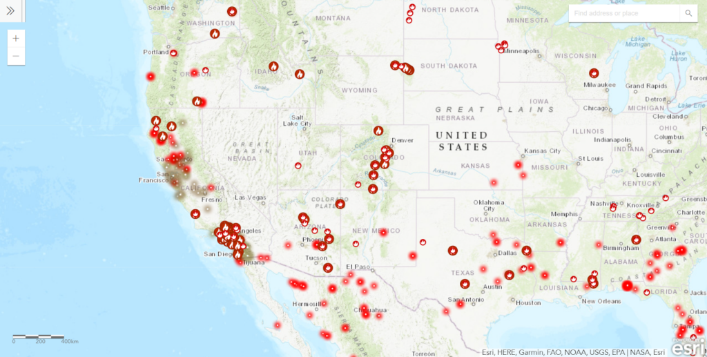
For example, after the California wildfires, government agencies can analyze historical mobility data to understand which evacuation routes were most heavily traveled. This insight helps inform future emergency planning by identifying where to reinforce infrastructure, or stage resources for faster, safer evacuations.

Source: Frontline Wildfire

By using real-time location data, governments can improve public safety planning, ensuring that resources and interventions are allocated where they are needed most.

Transportation Planning

Transportation planning greatly benefits from mobility location data, particularly when addressing traffic congestion and optimizing public transport routes. 

By analyzing real-time traffic flow, transportation authorities can pinpoint congestion hotspots and find alternative routes to minimize delays, improving the overall commuter experience. 

This data can also guide infrastructure development, such as building new roads or expanding public transport in high-demand areas. 

With the mobility data gathered, city authorities can:

  • Optimize bus and train schedules
  • Improve pedestrian safety 
  • Promote environmentally friendly transport options like biking or walking

By tracking movement patterns, authorities can prioritize projects that will most effectively reduce traffic congestion, improve air quality, and make travel easier for residents.

Experience the Power of Localized Insights with dataplor

Mobility location data is a game changer for both businesses and public sector initiatives, enabling localized strategies that deliver tangible results.

With high-quality location intelligence, organizations can unlock opportunities, optimize operations, and create solutions to meet the changing needs of their audience.

At dataplor, we provide comprehensive, reliable datasets so you can make informed decisions. Our data is tailored to a wide variety of industries and sectors, offering unmatched granularity and coverage.

With dataplor, you can say goodbye to lengthy data collection processes, seamlessly integrate our datasets into your existing systems, and process data your way to get the insights you need most.

Benefit from:

  • High-Quality Data: Complete and accurate datasets for diverse use cases.
  • Custom Data Feeds: Get the data you need, in the format that suits you best.
  • Unbeatable Support: Our team will give you the tools and guidance to help you maximize your data’s potential.

Ready to buy location data from a data provider and supercharge your localized strategies, saying no to irrelevant third-party data sources? 

Talk to an expert today or request a free data sample to experience our services and see how we compare to other data providers. 

So, what are you waiting for?

Get in touch with dataplor today and start unlocking precise, actionable insights to achieve your objectives. 

Get the full story

Subscribe for the latest on location intelligence, places data, and the trends behind better business decisions.

Subscribe
How the UK’s Top Grocery Chains are Evolving: Growth Stories from Aldi, Tesco, and Sainsbury’s

Blog

How the UK’s Top Grocery Chains are Evolving: Growth Stories from Aldi, Tesco, and Sainsbury’s

Geoff Michener
 May 07, 2025  •  5 min read

The UK grocery market has always been fiercely competitive, but over the past five years, the landscape has shifted in fascinating ways. Behind every new store, every closure, and every strategic move lies a story of adaptation, ambition, and long-term vision.

In today’s high-stakes retail environment, understanding where and how brands grow is essential. For investors, real estate developers, and portfolio managers, understanding these growth stories is more than an academic exercise—it’s critical to making smarter location-based decisions.

That’s why dataplor has partnered with Cherre, the leading real estate data management platform. By combining dataplor’s global location intelligence with Cherre’s real estate data integration capabilities, investment management and real estate firms can unlock powerful, location-based insights—especially for private chains that don’t share public disclosures. With Cherre, firms can easily combine dataplor’s point of interest data with a client’s internal portfolio data, and other third-party datasets to enable:

  • Smarter site selection based on competitor proximity and retail growth patterns
  • Visibility into openings, closures, and market shifts—especially from private chains like Aldi
  • Custom investment models incorporating retail density, geospatial trends, and foot traffic insights

To illustrate how this works in practice, we analysed five years of store growth trends for three of the UK’s leading grocery brands: Aldi, Tesco, and Sainsbury’s. Instead of just counting stores, we looked at the why and where behind their expansion. The patterns reveal not only the strategies of these retailers, but also the opportunities they create for those looking to invest, build, or compete in these markets.

Aldi: The Challenger That’s Not Slowing Down

Few grocers have disrupted the UK market quite like Aldi. With a no-frills, value-first model, Aldi has shown consistent momentum with targeted bursts of expansion.

From 2020–2024, Aldi averaged a strong 4.9% annual growth rate in store openings. The brand kicked off the decade with 5.5% growth in 2020, followed by a peak of 6.4% in 2021. In 2022, the pace moderated to 4.7%, and 2023 saw a notable slowdown to just 0.8%, signaling a strategic pause. But in 2024, Aldi delivered an impressive 8.5% growth—its strongest performance in five years.

This cadence isn’t random. dataplor’s analysis suggests that the 2023 pause represented a deliberate period of site selection, planning, and operational optimisation. The result? A sharp rebound that underscored Aldi’s renewed confidence in capturing more market share.

Proximity Patterns: Retail Neighbors of New Aldi Locations

Our initial geospatial analysis highlighted Aldi’s 2023 slowdown and rapid acceleration into 2024. With dataplor’s location intelligence layered into Cherre’s platform, we were able to take the next step: examining the specific characteristics of Aldi’s 2024 store locations to uncover meaningful insights about their selection strategy. The goal was simple, to understand not just where Aldi is growing, but the underlying factors shaping those decisions. 

dataplor analysed the types of POIs and most common chains within 400m and 2km of the 80+ new Aldi locations that opened in 2024.

Interpretation:

  • Allpoint and InPost: Aldi strongly favors utility-dense areas, ensuring customers have access to both cash and parcel services.
  • Sainsbury’s presence supports the idea Aldi is not avoiding competition but rather positioning itself in established grocery zones.
  • Motability Scheme proximity highlights a potential bias toward vehicle-accessible locations, perhaps in suburban commercial strips.

Chains Disproportionately Concentrated Near Aldi Stores

These chains appear almost exclusively within 400m and not in the wider 2km trade area, indicating Aldi may be deliberately co-locating near:

  • InPost Lockers
  • Motability Scheme Locations
  • Evri ParcelShops
  • Boots Pharmacy
  • McDonald’s, KFC, Timpson (key service and fast-food chains)

Top 5 Most Common POI Types Within 400m:

  • Bus Stops
  • ATMs
  • Beauty Salons
  • Restaurants
  • Corporate Offices

Strategic Implications

Aldi appears to be selecting new store locations with the following characteristics:

  • High Accessibility: The presence of many bus stops suggests Aldi prioritizes locations with strong public transportation access, which can drive foot traffic and accessibility.
  • Financial Convenience: Proximity to ATMs may indicate a preference for areas with available financial services, supporting quick cash access for customers.
  • Community-Oriented Retail Zones: Beauty salons and restaurants point toward Aldi targeting areas that function as local commercial hubs with steady daily activity.
  • Business Districts: The number of nearby corporate offices implies Aldi may be placing stores in or near employment centers, perhaps targeting lunchtime or post-work shopping traffic.

Tesco & Sainsbury’s: The Competitive Backdrop

While Aldi pushed aggressively into high-density commercial zones, Tesco and Sainsbury’s opted for more measured strategies over the same five-year period.

Tesco saw 3.6% growth in 2020, followed by 1.9% in 2021. Growth rebounded to 3.5% in 2022, then held steady through 2023 (3.2%) and 2024 (3.4%). dataplor’s insights revealed a trend of store closures during the later years of this period, highlighting a strategic reshuffling. Tesco appears to be fine-tuning its presence, prioritizing profitability and precision over rapid expansion.

Sainsbury’s, in contrast, followed the most conservative path. From 1.3% growth in 2020 to 2.8% in 2021, the brand dialed back slightly in 2022 (1.5%), rose again in 2023 (2.7%), and stayed consistent in 2024 (2.4%). These moderate, consistent figures reflect a company focused on stability, closing underperformers while reinforcing key strongholds.

Together, these approaches illustrate the broader market context Aldi is navigating and disrupting.

The Future of Growth is Data-Driven

The evolution of the UK grocery sector over the last five years is more than a story of new openings or market share battles—it’s a story of strategic intent.

dataplor’s location intelligence makes it possible to see beyond the headlines. We offer a detailed, dynamic view of store growth, site selection, market saturation, and competitive positioning in real time. With our integration into Cherre’s platform, it’s easier than ever for real estate and investment firms to put that intelligence into action.

Let’s explore what’s possible. Contact us to learn how dataplor and Cherre can help you unlock the full power of location intelligence—wherever your next move takes you.

Get the full story

Subscribe for the latest on location intelligence, places data, and the trends behind better business decisions.

Subscribe