
Industry leading POI and mobility data for geospatial applications
Enhance customer satisfaction, avoid costly errors, and grow your product anywhere in the world by enriching your geospatial stack with the leading international places dataset.

Unlock spatial intelligence with global location data
Our global point of interest (POI) and mobility data supports geospatial platforms for companies in a variety of verticals, from ride-hailing and food delivery to fintech, logistics, and telecommunications. With our POI data as their foundation, leading organizations in these sectors are able to build top-notch products their customers can rely on.
Leverage location & brand intelligence to enhance your geospatial applications

Increase customer satisfaction
Dataplor’s POI and mobility datasets provide geospatial developers with the information they need to create maps that are accurate, reliable, complete and useful for their end users. Whether these users are ride-share drivers or food-delivery contractors, each requires verified points of reference to meet and exceed consumer expectations. Companies that use GIS platforms running on Dataplor’s location data can promise precise travel estimates and on-time arrivals.
Learn More
Avoid costly errors
For ridesharing and food-delivery companies, powering GIS platforms with bad data can be costly. Dataplor makes sure that you’ll limit expensive refunds due to incomplete addresses, imprecise geocodes, and incorrect pick-up and delivery times.
Learn More
Expand globally
International location data is notoriously error-prone. If you’re hoping to scale or enrich your GIS service, your geospatial data must be reliable. Dataplor gives you just that: truly global POI and visitation data that’s trusted by Fortune 500 companies around the world. Our enhanced and tailored datasets give you both a bird’s-eye and a granular view of market trends and business operations in any location.
Learn More
Streamline operations
Leaders from other industries can put location data to work to streamline operations. With places databases, for example, credit card companies stand poised to create stronger customer profiles and analyze or monetize transaction data. In the realm of logistics, POI data and GIS applications facilitate route optimization. With GIS layering supported by Dataplor, Telcos can gain insight into target audiences and make informed choices about how and where to build out their networks. These are just a few of the many ways organizations can leverage spatial data to streamline operations.
Learn MoreThe Dataplor advantage
Dataplor’s location intelligence is a powerful tool for improving the accuracy and efficiency of your GIS systems, as it covers a wide range of global regions, even those with limited data availability. Our data aligns with stringent privacy regulations, such as GDPR. We do not collect any Personally Identifiable Information (PII), ensuring that our POI and mobility data uphold user privacy and exceed traditional standards.
Learn How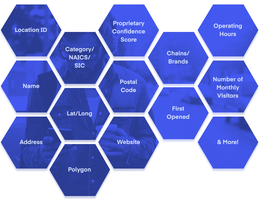
The building blocks for a great GIS
Dataplor’s best-in-class POI and mobility data delivers GIS providers and their users with truly global intelligence. This is because Dataplor uses a combination of technology, including proprietary AI and machine learning, along with human verification to ensure the accuracy of every dataset. Our tech-powered and human-verified data offer a unique blend of business details and geolocated data for any business location or region worldwide.